EarthObserver app for iPhone and iPad
Explore your planet as never before with the mobility of EarthObserver. Use your fingertips to travel through terrestrial landscapes and across the ocean floor. Visit frozen icecaps, study geological maps, scout mountains to climb and trips on coastal waters and exploit a rich atlas of other earth and environmental imagery.
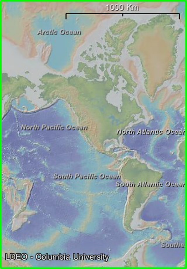
EarthObserver brings to you the latest compilation of detailed ocean floor relief gathered by oceanographic research ships using modern swath mapping technologies, combined with land elevations from satellite stereo imagery.
Features:
- World, North Polar, and South Polar views
- Zoomable interface from global scale to street and harbor scale
- Maps draped over topography with adjustable transparency
- Tap any map for its digital or text values
- The elevation anywhere - right at your finger tip
- Geographic names for land and ocean features
- Further educational content including data sources and suggested readings
- Data streamed to your device via Wi-Fi or 3G network
- Content cached locally after delivery so you can view it offline
- Instructions and Frequently Asked Questions
Content:
- Basemap (computer-generated color-shaded relief of land and ocean floor)
- US Coastal Bathymetry (with color palette appropriate to provide details of bays, sounds, estuaries, harbors and rivers)
- US Nautical Charts (paper raster and digital electronic at all scales for Atlantic, Pacific, Gulf of Mexico, Bering Sea, Arctic and Great Lakes)
- US Topographic Sheets (entire USGS collection for US mainland, Alaska, Hawaii and Puerto Rico)
- Geologic Maps (entire world, by continent, by country and by US state showing formation ages, names and rock types)
- Geophysical Maps (global earthquakes, tectonic plates and boundaries, gravity anomalies, geoid height, magnetic anomalies and the configuration of world stress)
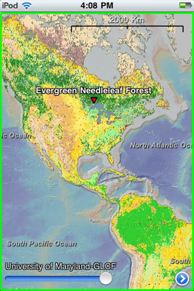
- Land Surface (temperatures day and night, primary productivity, vegetation index, land cover classifications and diversity, forest cover types and fragmentation)
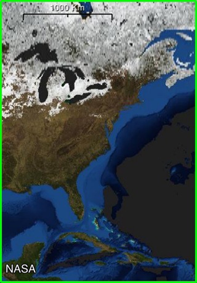
- NASA Visible Earth (global earth scenes for each month)
- Ocean Floor (crustal age, sediment types, sediment thickness, seabed heatflow, seafloor true color, seafloor spreading rates, manganese nodules)
- Ocean Surface (temperature, salinity, primary productivity, temperature during prior ice age)
- Human Impact (area per person, human footprint index, population density (2010), infant mortality rate, underweight children)
- Hydrology (river drainage basin outlines, drainage networks, river flow accumulation)
- Natural Hazards (cyclones, drought, earthquakes, floods, landslides, tornadoes, volcanic eruptions)
- Atmosphere and Clouds (aerosols, carbon monoxide, cloud fraction, cloud optical thickness, cloud particle radius, cloud reflectance, cloud water content, radiation, solar insolation)
- Snow, Ice and Water (ice cover, permafrost cover, snow cover, snow-water equivalent, water leaving radiance, water vapor)
- Shorelines and Political Boundaries (countries, provinces, states, maritime)
Developed by Lamont-Doherty Earth Observatory (Columbia University)
Columbia University continually seeks to advance the frontiers of knowledge and address the complex global issues of our time.
Pros and cons of EarthObserver app for iPhone and iPad
EarthObserver app good for
Not what I was looking for but happy found it. I was looking for a app that would show all of the world mining areas from potash, iron ore, gold and rear earths. The one thing is the previous may be in the app and I have not found it yet. Theres a lot and its free.
Im not a geologist, but this is such a cool app! The maps are very interesting for anyone who loves the discovery channel, I love all the ocean floor maps!
Some bad moments
Maps are not detailed
Cant zoom in to see basic details.
Some areas bottled out or fogged out basically I bout a smoke screen
Let me start by saying that I am already a very active user of LDEOs GeoMapApp, and it has helped me to locate high-resolution sonar data that I am currently using for my PhD research. Therefore, I was very, very excited when I heard this app was available.
The amount of layers and datasets available to overlay on the basemap is astounding, and the app is surprisingly fast. I can easily zoom into an area of interest and within a few seconds, the image has updated to show me the data at resolution appropriate for that zoom level. A green rectangle around the data indicates that you can zoom in for an even higher resolution image. A red rectangle means you have already maxed-out the resolution. You also have options to highlight where higher resolution data has been incorporated into the basemap just like in the GeoMapApp desktop version. When looking at sea floor data, the low resolution predicted bathymetry data will be slightly darker, and higher resolution multibeam sonar data from ship track lines will be brighter.
Within seconds of downloading the app, I was creating overlays with earthquake locations, getting actual depth estimates from the seafloor (a elevation in meters pops up when you click on the basemap) and saving out images.
The one quirky thing I noticed is the camera icon to save out a JPG image. The camera icon is located on the menu tab, accessible by clicking the > button. If you click the camera icon, you see the familiar screen flash that lets you know a screen grab has been taken. It appears that all you have done is taken a screen grab of the menu, but it actually takes a screen grab of the data that was viewable on your screen right before hitting the > button. I found this a bit counterintuitive as it seems that having the camera icon on the actual map view would make more sense, though it would take up a slight bit of screen real estate. That said however, the screen capture features works very well and screen grabs are automatically saved in your camera roll.
I cannot wait to get home and try this out on my iPad. I see this app being extremely useful not just to me, but to anyone in oceanography, geology, geophysics, or any type of earth science. Now, the next time Im in an impromptu meeting with my advisor sans computer and were discussing one of my focus sites, I can just pull out my phone and we can zoom right to to it!
Wow! This is simply amazing...the wealth of information and the various layers, colors, everything is outstanding. AND you can even take a snapshot of the screen...cool!
This has instantly become an essential app ... simply amazing.
Maps Illustrated w/ # of underweight children, carbon monoxide, human footprint, ocean floors, DAILY view from NASA... and more ! These nerds are awesome for making this & putting it up for free!
So much information in this free app. Great opportunities for students to make predictions & inferences and to draw conclusions.